حل مثالي لخادم تتبع السيارات وايلون لإدارة أسطول المركبات
تقدم امانكم ل- أجهزة تتبع السيارات أقوى خادم لتتبع السيارات في العالم وايلون لتتبع أحدث السيارات وأكثرها تقدمًا في خدماتها بالتعاون مع وايلون دبي ، حيث يمكن لـ سيرفر وايلون إدارة أسطول السيارات أو المركبات بسهولة من خلال العديد من المزايا التي يقدمها الخادم الذي سوف نتعرف به في هذه المقالة.
وايلون
Wialon – منصة تتبع نظام تحديد المواقع العالمي (GPS) تقدم خدمة مناسبة للشركات الناشئة والمؤسسات التي تتحمل المشاريع مهما كانت معقدة
هناك الكثير لنتحدث عنه في نظام تتبع الأسطول وإدارة السيارات من خلال أجهزة تتبع السيارات وServer Wialon وتطبيقاته، وكذلك في نظام المراقبة العالمي GPS TRACKER، حيث نقدم العديد من الخيارات التي تمكنك من تحقيق أقصى استفادة من إدارة أسطولك، كل هذا وأكثر مع Server Wialon الذي يوفر للعملاء: لوحة تحكم منفصلة لكل مركبة، تقارير محسنة، سياسات جغرافية، خرائط وآلة حاسبة).
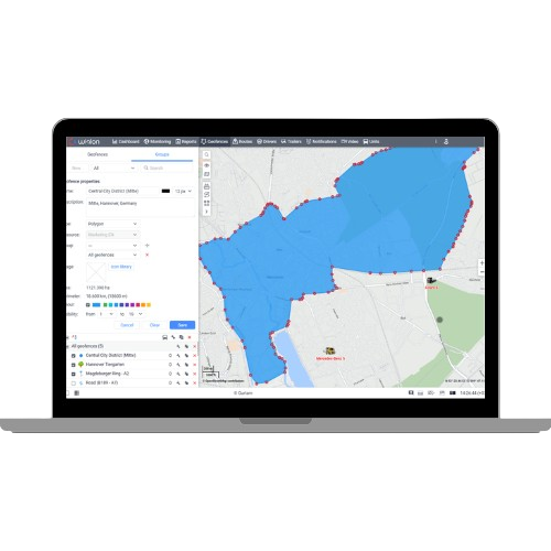
نظام إدارة أسطول المركبات مع خادم وايلون
يعد خادم Wialon لتتبع السيارات من أقوى أنظمة تتبع المركبات وإدارة الأسطول في العالم مع سهولة التحكم في المركبات من خلال الخيارات التي يوفرها الخادم وتطبيقاته. لقد قمنا بتحليل جميع أسماء أنواع الوحدات التي قدمها مستخدمونا بعناية وقمنا بإنشاء مكتبة عالمية.
الآن لا يحتاج المستخدم إلى اختراع أي شيء: في إعدادات الوحدة العامة، يختار المستخدم نوع الوحدة الصحيح من قائمتنا. إذا كانت الوحدة المحددة عبارة عن مركبة – يذهب المستخدم إلى أبعد من ذلك ويختار نوع السيارة المناسب في علامة تبويب الملف الشخصي.
سيتم عرض هذه الأنواع في نافذة خصائص الوحدة، وتستخدم كمرشح في نظام إدارة المحتوى وفي قائمة العمل، وتطبق لإنشاء التقارير، وتضاف كعامل جديد في الآلة الحاسبة، ولن يتم فقدان البيانات التي أدخلها المستخدم يدويًا – سيتم نقلها إلى حقل الملاحظات.
التقارير
تحسينات في التقارير من خلال المبارزة الجغرافية. في التقارير الجديدة لمجموعات السياج الجغرافي والسياج الجغرافي، أضفنا مرشحات جديدة: حسب المدة والمسافة المقطوعة والسرعة والسائق والمقطورة ومواقف السيارات والتوقفات
قيم المستشعر التالية في التقارير: المتوسط، الحد الأدنى، الحد الأقصى، درجة الحرارة الأولية، العداد النهائي، الأولي والنهائي، وزن الحمولة، إلخ؛ عمود مقطورة في جدول السياج الجغرافي؛ عمود السياج الجغرافي مع اسم السياج الجغرافي حتى يتمكن المستخدم من فهم السياج الجغرافي الذي تنتمي إليه الفواصل الزمنية المحددة. كل هذا سيساعد في جعل التقارير أكثر فائدة وسهلة الاستخدام.
الإبلاغ عن التحسينات من خلال السياج الجغرافي
رحلة الطريق من تقرير المجموعة. في التقارير الجماعية حسب الوحدات أضفنا إمكانية تحديد الفاصل الزمني للرحلة المحدد بالخط الأحمر وتبسيط الخريطة عليها عند تشغيل عرض جميع مسارات الركوب أو الرسائل على الخريطة. يمكن عرض الفاصل الزمني في جداول الرحلات وساعات المحرك والركوب وجداول السرعة للتقرير حسب مجموعات الوحدات وفي جدول الرحلات لتقرير السائق.
مجموعة تقارير الرحلة
علامة تبويب قائمة منفصلة للوحة القيادة. تعد لوحة المعلومات أداة منفصلة قوية ذات وظائف مفيدة، لذا تم وضعها الآن كعلامة تبويب منفصلة في القائمة الأفقية ولم تعد تفتح تلقائيًا. تظل علامة تبويب المراقبة في نفس المكان. يتم عرض البيانات الموجودة على لوحة المعلومات فقط للوحدات المضافة إلى قائمة العمل. علامة تبويب قائمة منفصلة للوحة القيادة
إدارة الكتل في صفحة لوحة القيادة. قمنا بتعديل إدارة أوامر blockchain في صفحة لوحة التحكم الرئيسية. الآن، من خلال تمرير عنوان الكتلة، يمكن للمستخدمين سحب أي كتلة إلى أي مكان. وبالتالي، أصبحت إدارة ترتيب الكتل على صفحة لوحة التحكم سهلة الاستخدام حقًا.

الخرائط
طبقات خرائط جورتام الجديدة. لقد أدخلنا نمطين جديدين من الخرائط، وكلاهما متجهان. يبدو تصميم خرائط Waylon وكأنه تصميم محدث وجذاب. وبصرف النظر عن المظهر الرائع، فإن أنماط المتجهات الجديدة أكثر تقدمًا من الناحية التكنولوجية. يتم تحميله بشكل أسرع ويسمح بإضافة ميزات مفيدة جديدة في المستقبل.
الخرائط
طبقات خرائط جورتام الجديدة. لقد أدخلنا نمطين جديدين من الخرائط، وكلاهما متجهان. يبدو تصميم خرائط Waylon وكأنه تصميم محدث وجذاب. وبصرف النظر عن المظهر الرائع، فإن أنماط المتجهات الجديدة أكثر تقدمًا من الناحية التكنولوجية. يتم تحميله بشكل أسرع ويسمح بإضافة ميزات مفيدة جديدة في المستقبل.
الأسوار الجغرافية
فرز السياج الجغرافي أثناء العرض. في السابق، كانت الأسوار الجغرافية تعرض بشكل عشوائي، وكان من المستحيل ترتيب عرضها إذا تداخلت. في بعض الأحيان، قد لا يكون السياج الجغرافي الصغير مرئيًا إذا تم عرضه أسفل السياج الجغرافي الأكبر.
يتم الآن فرز العرض على النحو التالي: تقع الأسوار الجغرافية من النوع الدائري الكبير والأسوار الجغرافية من النوع المضلع أسفل السياج الجغرافي الأصغر؛ تكون الأسوار الجغرافية من نوع الخط دائمًا أعلى من الأسوار الجغرافية الأخرى. فهو يسمح بالهروب من تداخل السياج الجغرافي غير المرغوب فيه ويضمن رؤية كل منهم.
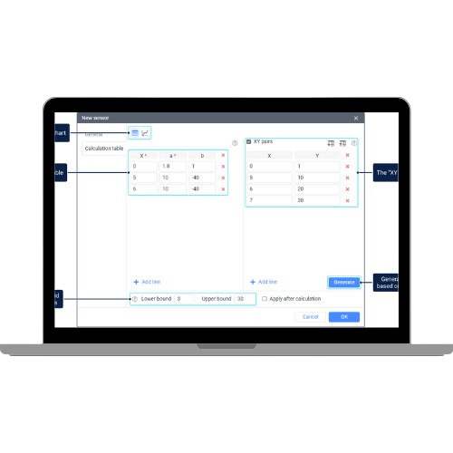
آلة حاسبة
إضافة محول إلى الآلة الحاسبة. غالبًا ما يستخدم مستخدمونا الآلة الحاسبة لتحديد مدة فترات زمنية مختلفة. في السابق، كانت نتيجة هذا الحساب تقدم في ثواني. لقد أضفنا محولًا يسمح بإنتاج النتيجة بتنسيق سهل الاستخدام: الساعات: الدقائق: الثواني، وكذلك بتنسيق التاريخ والوقت.
آلة حاسبة
إضافة محول إلى الآلة الحاسبة. غالبًا ما يستخدم مستخدمونا الآلة الحاسبة لتحديد مدة فترات زمنية مختلفة. في السابق، كانت نتيجة هذا الحساب تقدم في ثواني. لقد أضفنا محولًا يسمح بإنتاج النتيجة بتنسيق سهل الاستخدام: الساعات: الدقائق: الثواني، وكذلك بتنسيق التاريخ والوقت.
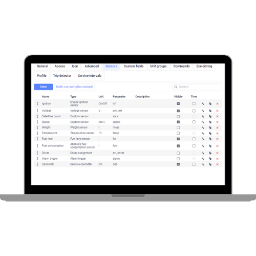
أجهزة الاستشعار
نقل إعدادات استهلاك الوقود إلى حساسات الوقود. بالنسبة للآلات الخاصة التي تحتوي على العديد من خزانات الوقود أو المحركات، قمنا بنقل إعدادات استهلاك الوقود إلى إعدادات مستشعر الوقود. الآن يوجد كل شيء في نافذة واحدة (إعدادات مستشعر الوقود المطلوبة).
معلومات إضافية. وكجزء من هذه المهمة، أضفنا أيضًا القدرة على توصيل أجهزة الاستشعار بأجهزة الاستشعار (أجهزة استشعار المحرك بـ FLS، وأجهزة استشعار كفاءة المحرك بأجهزة استشعار المحرك المحددة)؛ قم بتوسيع حساب استهلاك الوقود عن طريق الرياضيات لـ FLS، وقم بتغيير عملية الاستيراد والتصدير لكل من أجهزة الاستشعار والوحدات بأكملها، بحيث يمكنك، على سبيل المثال، استيراد الوحدات المصدرة مسبقًا بشكل صحيح. أضفنا أيضًا أعمدة جديدة لاستهلاك الوقود إلى بعض الجداول للحصول على معلومات أكثر اكتمالاً حول الوحدة أو مجموعة الوحدات.

اللوجستية
احسب تكلفة الطريق. أضفنا القدرة على حساب التكلفة الإجمالية للمسار. يتم عرضه في الخطوة الثالثة من التخطيط وفي علامة تبويب الطريق. في إعدادات التطبيق في علامة التبويب “التخطيط”، هناك كتلة جديدة حيث يمكنك تحديد تكلفة المعلمات الرئيسية للطلب: التكلفة لكل كيلومتر واحد، وساعة واحدة، وطلب واحد، وترك السيارة. إذا تم تحديد عدة طرق، سيتم تلخيص نتائج الحساب. ستساعد البيانات الواردة في حساب فعالية التكلفة مما يسمح بتخطيط المسارات بتكلفة أقل.
طرق فعالة وفعالة. ستجد في التقارير خيارًا جديدًا لعرض المسارات القادرة والفعلية على الخريطة. الآن، عندما تجد تناقضًا بين الأميال المقدرة والفعلية في التقرير، يمكنك الضغط على زر عرض المسار ورؤية مسارات المسار على الخريطة. علاوة على ذلك، عند النقر على أيقونة الطلب على الخريطة، يمكنك رؤية معلومات مفصلة حول الطلب المحدد.
أدخل الحقول المخصصة. أضفنا القدرة على إنشاء حقول مخصصة تحتوي على أي معلومات إضافية حول التسليم. في الإعدادات، توجد علامة تبويب جديدة للحقول المخصصة حيث يمكنك إنشاء العديد من الحقول المخصصة حسب حاجتك. يتم عرض الحقول المضافة في الإعدادات في قسم منفصل في مربع حوار إنشاء الطلب وكذلك في جدول الطلب حيث يكون لكل اسم حقل وقيم أعمدة منفصلة. يسمح بتغيير ترتيب الأعمدة في الجدول وفرز المعلومات في كل عمود.
يتم نشر نظام المراقبة على الخادم الخاص بك أو خادم العميل. نحن نقدم الوظائف الكاملة لتتبع نظام تحديد المواقع العالمي (GPS). أنت تدفع فقط مقابل تلك الوظائف التي تستخدمها بالفعل. يعمل حل تتبع نظام تحديد المواقع العالمي (GPS) مع 2300 نوع من الأجهزة. في معظم الحالات، يجب تثبيت أجهزة جديدة أو يمكنها العمل مع الأجهزة المثبتة بالفعل.
يدعم Wialon أجهزة محددة للمركبات والآلات والأصول الثابتة والأشخاص حتى تتمكن من العثور على جهاز اتصال مناسب لأي مشروع. يقرأ الجهاز الإضافي درجة الحرارة والوزن والزاوية وعشرات من معلمات المراقبة الأخرى لإجراء تحليلات متعددة الأوجه.
معلومات إضافية. وكجزء من هذه المهمة، أضفنا أيضًا القدرة على توصيل أجهزة الاستشعار بأجهزة الاستشعار (أجهزة استشعار المحرك بـ FLS، وأجهزة استشعار كفاءة المحرك بأجهزة استشعار المحرك المحددة)؛ قم بتوسيع حساب استهلاك الوقود عن طريق الرياضيات لـ FLS، وقم بتغيير عملية الاستيراد والتصدير لكل من أجهزة الاستشعار والوحدات بأكملها، بحيث يمكنك، على سبيل المثال، استيراد الوحدات المصدرة مسبقًا بشكل صحيح. أضفنا أيضًا أعمدة جديدة لاستهلاك الوقود إلى بعض الجداول للحصول على معلومات أكثر اكتمالاً حول الوحدة أو مجموعة الوحدات.
Wialon
Wialon Server Features for Car Tracking
Access to servers
Server data, backups and settings are always within reach
Built-in metrics
No need to use third party tools to monitor server efficiency
Easy management
We add Debian Linux to each distribution package
Reasonable workload
Average server storage capacity reaches 20,000 units
Protection
Updates, troubleshooting and Wialon Local restarts can be done without sharing the system’s integral two-factor authentication protection and password protection using the comprehensive search method
Electronic Monitoring Units
Fuel Consumption Control
Driver Behaviour Analysis
Guidance Service
Strong Analytics
Notifications
Easy-to-use management
Working with Tacograf Data
Response to any events per second
Calculate fuel consumption with maximum accuracy
Reduce mileage and time to reach destination
Improving working hours rather than expanding the team
Analyze more data than a tracker can offer, or a CAN carrier
Tracking assets and events within the specified area
Prevention of accidents and heavy corrosion of machines
Watch the road and the driver with your eyes
Wialon meets 99% customer needs. The remaining 1% is for each separate business. That’s why we’ve added 20 business-specific apps to the Wialon server production line to make the complete solution truly global, as the Wialon vehicle tracking software comes with a scheduled transportation management solution, delivery control service, maintenance management application, driver behavior monitoring unit, and much more.
Your customers access the system from anywhere, the operating system doesn’t matter: whether you’re using MacOS, Linux or Windows, run a browser to start tracking.
Use your smart devices: We offer an original mobile app to start tracking on a smartphone or tablet.
Tracking events by SMS and email: The notice describes in detail what happens with your assets.
Use your smart devices: We offer an original mobile app to start tracking on a smartphone or tablet.
Tracking events by SMS and email: The notice describes in detail what happens with your assets.
Wailon offers partners a fuel accounting algorithm. If you know the prices, you can show customers the actual fuel spent under different conditions determined by mathematics. Moreover, you can create virtual FLS files that are as accurate as physical accuracy.
In addition, as a GPS tracking service provider, you can expand the trade display through 20 GIS sources, the WiaTag tracker app, and the report processor to integrate 180 schedules and charts for maximum accurate analysis.
Allocation of application to work needs; Prepare the required cases and get messages with customized parameters to find out what is happening in this area. In addition, as a GPS tracking service provider, you can expand the trade display through 20 GIS sources, the WiaTag tracker app, and the report processor to integrate 180 schedules and charts for maximum accurate analysis.
Allow workers to log in using the QR code. Ask them to scan QR codes at certain points or positions (e.g., at the end of the road).
Let workers use user modes that consume different amounts of battery power; Offer energy saving mode to make devices last longer.
Customize Wialon interface elements to be used as your brand. Apply for the GPS tracking platform’s white label option for opportunity and modification:
Wialon’s system of colors and lines for car tracking;
Logo login page and background;
Texts (page title, link to documents, link to support team, etc.).
The following modifications are also available: you can change the location of the map while logging into the system, the demo registration link on the login page, the interface language menu, and customize the report.
Want to get a white card option? Feel free to ask for it now.
Show the main tracking parameters on the home screen for quick checks. The data is automatically updated according to the latest messages from the unit.
Workers can send photos, SOS messages or location information. You are notified of situations where individuals need help or instructions.
Choose pre-set mode (active/standard/light) or create your own mode (custom).
Order actions such as camera shot or stop service and change remote application settings to proactively guide workers.
Sending and receiving various types of messages from field workers for close and detailed daily communication.
What you need to start build your own eco-monitoring system without using additional devices. Use workers’ smartphones as tracking devices, account in Whalon, GPS smartphone, internet service yatag, mobile chip, tracking device.
Wialon is a GPS and IoT monitoring platform that tracks more than 2.7 million mobile and fixed units in more than 130 countries worldwide and consists of more than 1,900 partner companies, 600 hardware manufacturers and hundreds of Wialon-based solution developers. With our system, you can offer any surveillance project, whether it relates to transport (land, sea, river, etc.), buildings, people, not just all connected units * are on the map! You can find our partner offices on Wialon’s global partner map.
Hectera - A New Solution for Agriculture
- Monitoring crop rotation and fieldwork with hectira.
- How the GPS system works in agriculture
- Import of geographical fences as fields; Create trailers, drivers and units in Wialon for further use in Hecterra
- Filling crop catalogues, processes and crops
Approval or refusal of discovered field farming - Establishment and export of comprehensive reports on field operations Fields and crops
- Import and create fields. Monitor crop rotation, crop catalogue and detailed history of agriculture for each field. Field Agriculture
- Detection of new field cultivation. Options for modification and approval of agriculture before being added to the Registrar.
Fleetrun - A Solution for Maintenance Management
Web application for planning, monitoring and recording maintenance expenses.
How fleet maintenance management system works
Create a list of units
Select the service interval
Add services: works and spare parts
Analysis of maintenance process with the assistance of reports and notifications
خادم وايلون
تم تصميم NimBus للتحكم في المركبات ذات الطرق الثابتة، ويتكون حل تتبع GPS الجديد للنقل العام NimBus من الوظائف الأساسية لبرامج تتبع الأقمار الصناعية والأدوات المتخصصة المصممة لإدارة المسار. استخدم الخدمة لإنشاء محطات إيقاف وتحسين المسارات وتوزيع المركبات عبر المسارات وإدارة الجداول وتتبع الأداء في الوقت الفعلي. يتميز NimBus بالتنقل البديهي والواجهة السهلة الاستخدام والجدول الزمني السهل والإشعارات القائمة على الأحداث للتتبع عبر الإنترنت ونظام ACL الخاص وواجهة برمجة التطبيقات لتكامل برامج الطرف الثالث والتطورات المخصصة.
The service allows a wide range of tasks in logistics and delivery – transportation arrangements, improved delivery path and cost savings. Logistics consists of a web version for senders and a mobile app for drivers. Web release ensures effective operating procedures management: order mode, planning, distribution, Google Maps-based guidance, delivery control and coordination. Mobile logistics application is designed for connectors and mobile staff.
Add Orders
Distribution of applications
Delivery Control
Generating Reports
Set the case for an order (delivered/rejected) and visit contact the customer.
Put the delivery route to order using external navigation applications.
Show the main tracking parameters on the home screen for quick checks. The data is automatically updated according to the latest messages from the unit.
Allocation of application to work needs; Set up required cases and get messages with customized parameters to find out what’s going on in this area.
Order actions such as camera shot or stop service and change remote application settings to proactively guide workers.
Sending and receiving various types of messages from field workers for close and detailed daily communication.
Online vehicle tracking is the ultimate solution to enhance fleet efficiency and productivity. If heads of companies with portable assets do not apply for online surveillance, they often face innumerable difficulties with the vehicle’s ineffective use, fuel theft and unfair implementation.
Wialon allows fleets and mobile online workforce to improve your costs and improve driver accountability. The system ensures control of different units – from traditional transport to family pets.
The fuel controller is designed to calculate fuel consumption in any type of machine, from vehicles to packing trucks.
Add comments and photos to the order.
Useful conversation to notify the sender of any circumstances relating to delivery.
WiaTag converts a mobile device into a tracker that monitors its owner: WiaTag turns your smartphone into a GPS tracker: The WiaTag app manages the mobile workforce efficiently. Due to accurate speed detection and detailed movement history of the unit, WiaTag is designed to improve field operations and mobile staff performance and control, the app is free to download.
Allow workers to log in using the QR code. Ask them to scan QR codes at certain points or positions (e.g., at the end of the road).
Let workers use user modes that consume different amounts of battery power; Offer energy saving mode to make devices last longer.
Choose pre-set mode (active/standard/light) or create your own mode (custom).
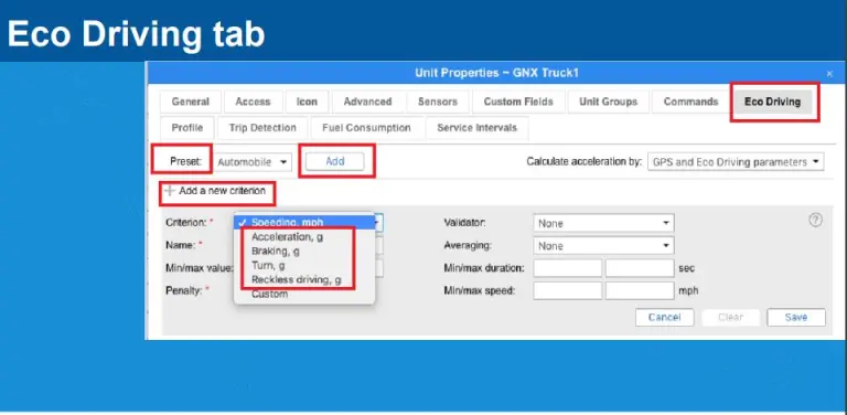
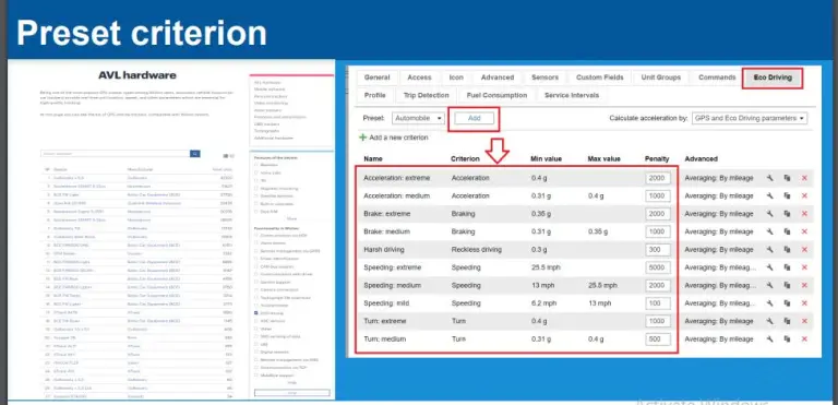
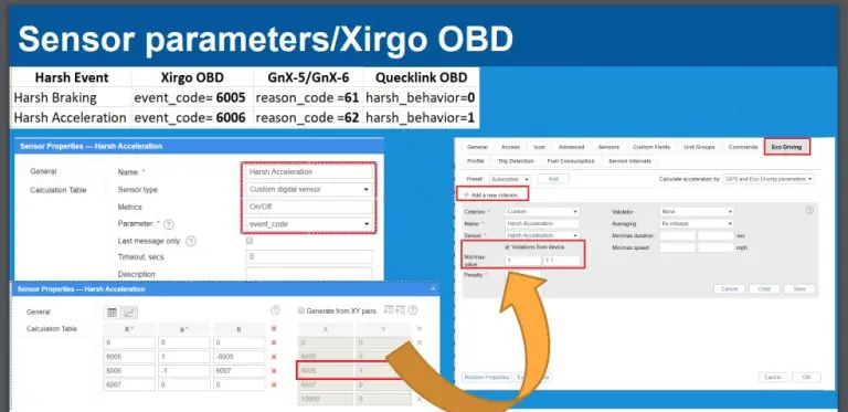
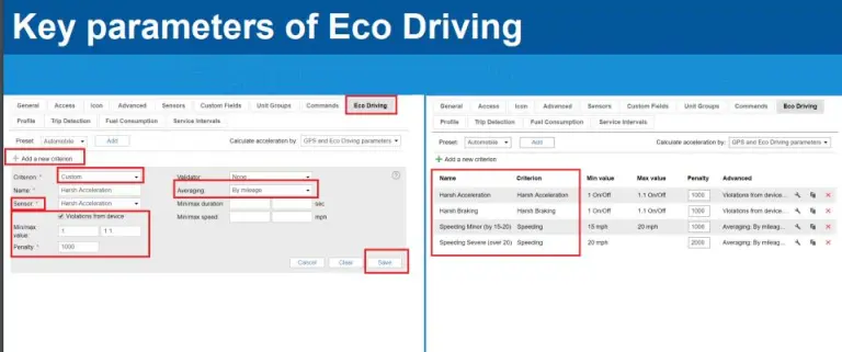
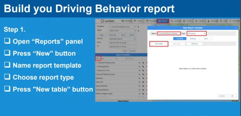
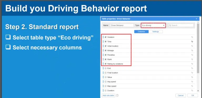
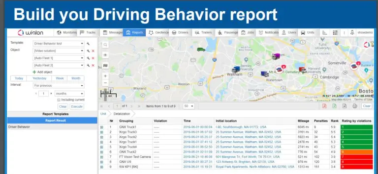
Eco Driving – The solution for driving quality control.
Wialon collects data from sensors installed in vehicles and sends them to the Eco Driving app.
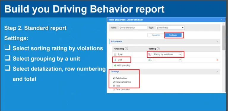
In Wialon, the user selects driving quality assessment parameters.
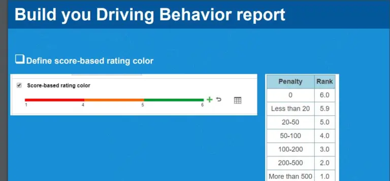
In Wialon, the user also assigns the number of penalty points per parameter, thus forming a driving quality assessment system.
The app shows the driver’s assessment, the number of violations, builds the path on the map, and shows where these violations are detected.
In driver tracking software, the user creates reports based on the information collected.
The user leverages data from reports to improve staff members’ driving skills and facilitate passenger and cargo transportation.
Parameters for assessing driving behavior: The choice of determining parameters for analyzing driving behavior: acceleration, braking, speed, reckless driving, acceleration during turning. Eco Driving can track other violations depending on the sensors created.
At Wialon Car Tracking Server a unit is used to track unit movements, control critical working conditions, manage devices by commands, receive notifications, and much more.
The unit’s location, history and control of the movement milestones;
Track a specific set of unit parameters, such as motion speed, fuel level, temperature, etc.
Management units (order execution, automatic functioning) and mobile workforce (text communications, calls, appointments and order management)
Unit activity notifications
Control of unit track performance
Analyze and interpret unit data via reports (tables and charts) and much more.
Flexible online monitoring capabilities
Wialon’s online vehicle tracking solution offers really flexible fleet and asset tracking capabilities. The system is fully customizable, which provides specific solutions to address any commercial problem. Wialon’s online surveillance solutions allow for
Create and set up accounts quickly, assigning rights to use specific system functions with the help of the CMS interface (customer management system).
Use almost any type of GPS/GLONASS device and variety of external sensors, including temperature sensors in refrigerated trucks and consumer goods trucks.
Choose favorite map layers, including OpenStreetMap, Yandex Maps, Google Maps, Bing Maps, Yahoo Maps and Gurtam Maps for Geographic Information.
Analyze sensor values, speed of movement and any other online module data.
View and improve the methods of individual or multiple units displayed as tracks on the map.
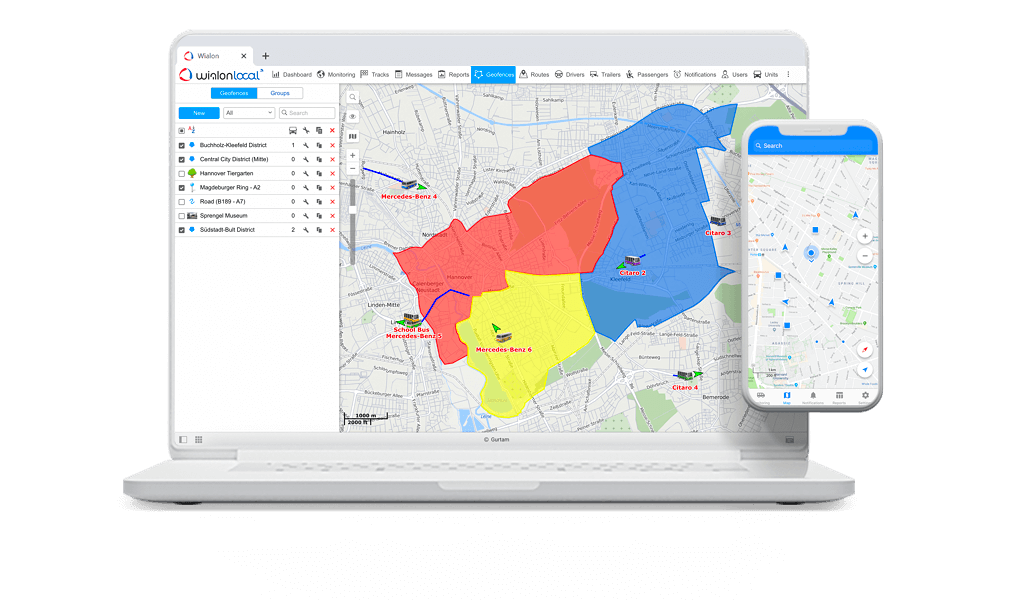
Establish a geographic fence and observe visits, and receive immediate notifications when the unit enters/leaves the geographic fence.
Use the “Pathways” tool to track vehicles or mobile workforce tracking roadpoints.
Analyze driver behaviour and identify reckless driving using the economic driving module.
Electronic driver records, accurate odometer reports, and mileage meters to ensure the driver’s compliance.
Track fixed and mobile assets using cell tower based positioning option when the GPS signal is weak or unavailable.
Create links and share the site for personal tracking or mobile workforce management purposes.
Get relevant data from online modules using the Wialon mobile app for iOS and Android platforms.
The Wialon system allows users to set up events (speed limits violations, fuel filling and alarm button activation) as triggers for notifications. Notifications can be sent via email or SMS, displayed in a pop-up or delivered as payment notifications via the Wialon mobile app on the smartphone.
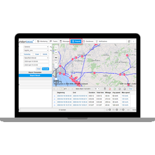
Wialon is able to process and analyze any data from units, show them in reports and visualize them as graphs. The user can choose the contents of the report by preparing the report templates. Reports can be created for one unit or module group: flexible settings provide you with relevant information.
التحكم في الوقود مع وايلون
تواجه الشركات ذات الأساطيل الكبيرة حتما مشكلات في إدارة الوقود. هناك سبب وجيه لذلك: غالبًا ما تكون تكاليف الوقود جزءًا كبيرًا من إجمالي نفقات الأسطول. وفي هذه الحالة، فإن نظام الرصد الساتلي للتحكم في الوقود هو الحل النهائي لتحسين حساب النفقات.
يعتمد نظام إدارة الوقود على البيانات المتاحة من جهاز الكمبيوتر الموجود على متن الطائرة أو أجهزة استشعار مستوى الوقود بعد البيع في السوق، المثبتة في خزان وقود السيارة. تسمح البيانات المنقولة إلى نظام التتبع بالكشف عن سرقات الوقود أو احتراق الوقود الكبير بشكل غير معقول، مما يساعد على إيجاد طرق لتوفير 15٪ أو أكثر من تكاليف الوقود وزيادة كفاءة الأسطول بنسبة 30٪ أو أكثر. وفقا للإحصاءات، فإن تنفيذ نظام تتبع أسطول السواتل سيرفر وايلون للتحكم في الوقود يدفع نفسه في غضون 3-4 أشهر.
تطبيق وايلون
بواسطة الأدوات الذكية، يسمح نظام خادم إدارة الوقود وايلون للمرسل المشغل برؤية تاريخ التغييرات في مستوى الوقود في خزان السيارة لفترة محددة، ويتم تقديمه كرسم بياني.
يتيح لك النقر فوق أي نقطة في الرسم البياني رؤية القيمة الدقيقة لمستوى الوقود وموقع السيارة في الوقت الحالي. يستند التحليل إلى بيانات من أجهزة استشعار مستوى الوقود بعد السوق (FLS) أو الكمبيوتر الموجود على متن الطائرة (CAN).
يتيح تتبع الوقود من ويلون الفرصة لإعداد تقارير عن جميع عمليات تعبئة الوقود وسرقات الوقود المحتملة مع تحديد التاريخ والوقت والموقع وعلامات الخرائط ومستويات الوقود الأولية والنهائية ومعلومات التغليف/السرقة المقدمة. باستخدام هذه البيانات الذكية، يمكن لمالكي أسطول البيانات عادةً تقليل سرقات الوقود في أسطولهم بنسبة 90٪.
باستخدام التقارير الخاصة في نظام خادم وايلون، يمكن للمرسل تحليل الاستهلاك الفعلي للوقود للمركبة لأي فترة معينة، ومقارنة القيمة بالمعيار، وتقييم الوفورات وحرق الوقود على الفور لكل مركبة ولكل أسطول.
بعد تعديل نظام التحكم في الوقود وفقًا لاحتياجاتك، يمكنك تلقي إشعارات حول تعبئة الوقود وسرقات البريد الإلكتروني والرسائل القصيرة وإشعارات الدفع على هاتفك الذكي باستخدام تطبيق وايلون موبايل الأصلي المتاح لنظامي Android و iOS، وعرض المعلومات حول مستوى الوقود الحالي السيارة. يمكن لأولئك الذين يفضلون التتبع في الوقت الفعلي استخدام تطبيق لوحة التحكم لتتبع مؤشرات الأداء الرئيسية ذات الصلة في الوضع في الوقت الفعلي.
يساعد نظام إدارة الوقود في وايلون في القضاء على أي إساءة استخدام للوقود، وزيادة سلامة النقل وتقليل نفقات استهلاك المركبات مما يزيد في النهاية من عائد الاستثمار.
Tacho View هو أداة أصلية لبرنامج خادم وايلون لتحليل Tacograph الذي تم إنشاؤه لراحتك. يستخدم التطبيق خوارزمية محددة لحساب ساعات العمل بناءً على الخصائص التشريعية للمنطقة المعنية.
تم تطوير تطبيق Tacho View لتحليل البيانات المكتسبة من ملفات Tacograf. يستند تحليل Tacograf إلى معايير مثل القيادة والعمل والتوافر والراحة. يتم تقديم بيانات نشاط السائق بصريًا كـ «جدول زمني»، مما يسمح بتحديد الفترات اللازمة بشكل أسهل.
Tacho View is an original tool for Wialon server software to analyze Tacograph created for your convenience. The application uses a specific algorithm to calculate working hours based on the legislative characteristics of the area concerned.
The Tacho View app was developed to analyze data gained from Tacograf files. Tacograf analysis is based on criteria such as leadership, work, availability and convenience. Driver activity data is presented visually as a “schedule”, allowing for easier determination of the necessary periods.
يقدم خادم تتبع السيارة من وايلن تطبيقين متخصصين للعمل مع ملفات Tacograph وبيانات نشاط السائق:
يتم التركيز على قياسات المسافة والأنظمة القانونية المرتبطة بالمنطقة عندما يتعلق الأمر بسوق رصد السواتل. يحاول فريق خادم تتبع السيارات وايلون دائمًا مراقبة هذه الاتجاهات، وتعديل منتجاتهم وفقًا للظروف الناشئة لسوق تتبع GPS.
لقد وفرنا لعملائنا الفرصة لتنزيل ملفات Tacographic عن بُعد والتحكم في نشاط السائق على طول الطريق. يتم أداء الوظيفة بشكل فعال في أدوات تحليل Tacho Manager و Tacho View، كونها جزءًا من نظام Wialon.
يسمح تطبيق Tacho Manager المتاح في قائمة التطبيقات للوحة المراقبة باستيراد ملفات سجل السائق (ملفات DDD) إلى خادم وايلون، حيث يتم تخزين الملفات التي تم تنزيلها لفترة طويلة من الوقت لمزيد من التحليل لـ tacograph. تتوفر ملفات DDD يدويًا أو تلقائيًا.
يوفر Tacho View ثلاثة أنواع من التقارير عن نشاط الطاقم المعروضة في شكل قائمة.
«نشاط السائق»
وترد محتويات هذا التقرير في شكل جدول. من خلال اختيار التاريخ اللازم، يمكن للمستخدم رؤية نشاط السائق التفصيلي خلال فترة زمنية محددة.
«مخطط النشاط»
في هذه الحالة، تنقسم الفترة الزمنية المحددة إلى أيام، حيث تتميز الأنواع ذات الصلة من نشاط السائق بمؤشرات الألوان.
«انتهاك»
من خلال اختيار هذا النوع من التقارير، ستحصل على جدول به معلمات مثل تاريخ الانتهاك ووقت البدء ونوع الانتهاك والوصف الموجز والجاذبية. يمكن طباعة جميع الإدخالات أو تصديرها إلى ملف اكسل. يسمح لك برنامج خادم وايلون للتحليل التكتيكي بالحصول على معلومات شاملة عن نشاط السائق وضمان الامتثال لقواعد التفويض. تسمح هذه الأدوات بالكشف عن انتهاكات القواعد المحتملة، وبالتالي المساعدة في تحسين سلامة الطاقم وتقليل العقوبات المفروضة على السائقين والشركات لانتهاكهم القواعد.
Monitoring driver's behavior and obtaining driving behavior reports: video and photo step by step